Introduction
위치 | 서울특별시 용산구 한강로 1가 231-22 일원, 삼각맨션부지 특별계획구역
용도ㅣ주거시설, 복합단지
대지 면적 | 20,860㎡
층수 | B4F – 25F
Location | 7, Daehak-ro 8-gil, Jongno-gu, Seoul
ProgramㅣResidential, Mix-used Complex
Site Area | 20,860㎡
Floors | B4F – 25F
Brief
본 프로젝트는 용산 내 거대 인프라(군사 시설, 철도, 대로)로 인해 발생한 도시적 단절을 분석하고, 이를 수용·확장하여 새로운 주거 군집의 DNA를 제안하는 시뮬레이션 과정입니다. 단순한 주거 단지 설계를 넘어, 단절된 도시의 틈을 메우는 입체적인 교차점을 제안합니다.
This project is a simulation process that analyzes the urban disconnection caused by Yongsan’s massive infrastructure (military facilities, railways, and major roads) and proposes the DNA of a new residential community that accommodates and expands upon this disconnection. Beyond simple residential complex design, it proposes a three-dimensional intersection that bridges the gaps in this disconnected city.
Concept


단순한 아파트 단지의 건축을 넘어, 주변의 서로 다른 속도와 표정들을 대지 안으로 끌어들여 도시 조직을 재구성합니다. 단절된 틈을 메우는 교차점이자, 주변 상황이 스스로 만들어내는 유기적인 주거 단지를 지향합니다. 또 대지 주변의 4미터의 고저차를 활용해 대지 안으로 자연스럽게 접근하는 보행 동선을 만듭니다.
Beyond the simple construction of an apartment complex, the project reconfigures the urban fabric by incorporating the surrounding landscape’s varying speeds and expressions into the site. It aims to be a crossroads bridging disconnected spaces, an organic residential complex shaped by the surrounding environment. Furthermore, the four-meter elevation difference surrounding the site is utilized to create a pedestrian path that naturally leads into the site.
Site

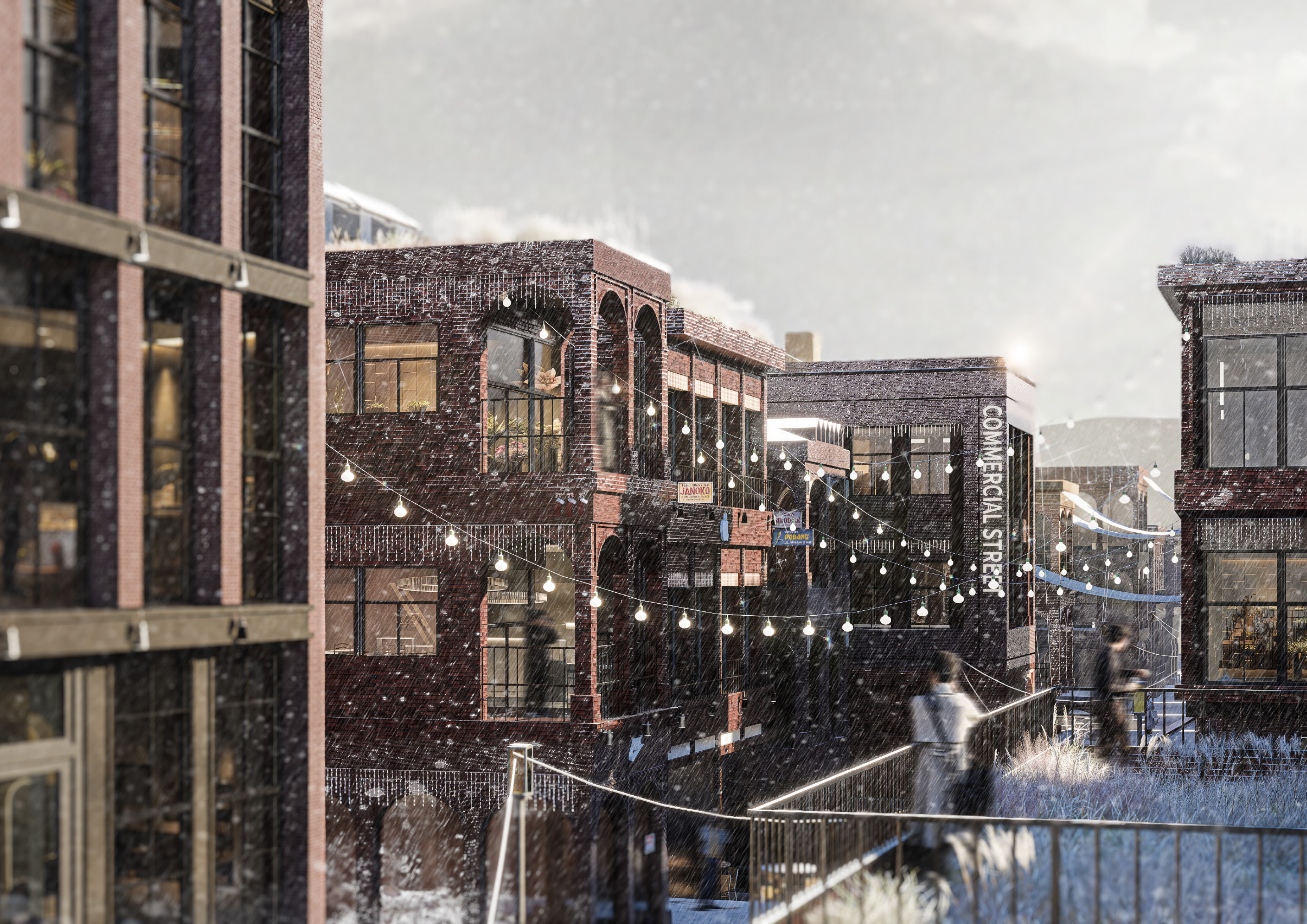
용산역과 삼각지역 사이, 40m 대로와 철도 개발, 군사시설로 둘러싸인 대지입니다. 거대 인프라에 의해 동서남북이 단절된 형세이며, 노후화된 저층 주거지(용리단길)와 고층 업무시설이 혼종된 독특한 맥락을 가지고 있습니다.
Located between Yongsan Station and Samgakji Station, this site is surrounded by a 40-meter-long boulevard, railway development, and military facilities. This massive infrastructure cuts off the area from all four directions, creating a unique mix of aging, low-rise residential areas (Yongridan-gil) and high-rise office buildings.
Design


막혀있던 주변의 도로망과 필지 구획을 대지 내부로 연장합니다. 이를 통해 물리적 단절을 해소하고, 다양한 성격의 보행자가 자연스럽게 유입되는 입체적인 보행 가로를 형성합니다.
The previously blocked road network and parcel divisions surrounding the site will be extended into the interior. This will eliminate physical isolation and create a three-dimensional pedestrian street that naturally attracts a diverse range of pedestrians.
Design Strategy


주변 건물의 디멘션, 간격, 층수 등을 분석하여 대지 내부의 기본 배치를 완성합니다. 용산 공원을 향한 그린 로드(Green Road) 확보를 위한 셋 백(Set-back), 상업축 활성화를 위한 요철 변형 등을 통해 도시 맥락에 대응하는 배치를 도출합니다.
We analyze the dimensions, spacing, and number of floors of surrounding buildings to finalize the basic layout of the site. We derive a layout that responds to the urban context, including setbacks to secure a green road toward Yongsan Park and irregularities to revitalize the commercial axis.
Site Plan

Drawings


Section


Unit


Image


credit
김동준 Dongjoon Kim + 정승엽 Seungyeop Jeong
4학년 2학기 4th Grade fall Semester Project
2025